Airspaces - Valle de Cauca, Colombia
Dear pilots,
I am sharing this information with the paragliding community with great frustration and fear that our beloved sport could become more restricted - or simply shut down all together - in the Cauca Valley as a result of our reckless behaviour, flying consistently through prohibited airspaces. I am tired of looking through tracklogs every night, to talk to every pilot who comes here uninformed or with the wrong airspace file, and thinks that after a 50-minute ride from Cali International Airport to Piedechinche take-off you can fly anywhere in the valley as you like, following the best-looking clouds into a CTR or TMA. Do you do that at home? I guess not.
The airspace situation fur us here is...let's be honest: a joke. Sadly, it is far from ideal or realistic and we are in great need of its reformation, but for the moment we need to play along in a way, that is sustainable until a better structure is in place.
Last season the conditions were epic with a couple of days with 3000m cloudbase and people were flying high in the middle of the valley, right in front of departing planes from Cali without even knowing. This needs to stop.
We either change the way we fly or we will never have a chance of negotiating a better deal.
PLEASE BEWARE:
1. OFFICIALLY: We are ONLY PERMITTED TO FLY in the dedicated areas for paragliding, called ZONA PARAPENTE (green on the second image below). These airspaces go from ground level to 1370 AMSL, 2290m AMSL and 3200m AMSL depending on the sector.
As soon as you exit these zones you are immediately violating TMA CAli, TMA Pereira or CTR Cartago/Pereira, or any one of the SKE or SKR airspaces (yellow on the second image below) reserved for military or private aviation training.
2. UPDATE YOUR INSTRUMENT'S AIRSPACE FILE:
ATTENTION: TMA Cali and TMA Pereira airspaces are not showing on Naviter devices and apps, nor on the airspace maps of https://flyxc.app/ and most likely many other devices by default!!! This misleads many pilots into only avoiding the CTR areas, while they are already violating the TMA.
Missing TMA Cali and TMA Pereira in the airspaces archive of FlyXC.app, Naviter devices and perhaps many others!
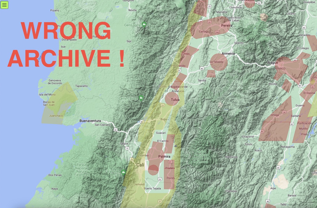
The real airspace structure of the Cauca Valley:
The airspace file is shown correctly in the XCTrack application (activate and update Colombia in the Airspace settings) and the https://airspace.xcontest.org/ website. If you are missing the complete airspaces file in your instrument please download the following file to your device on the bottom of this page or here.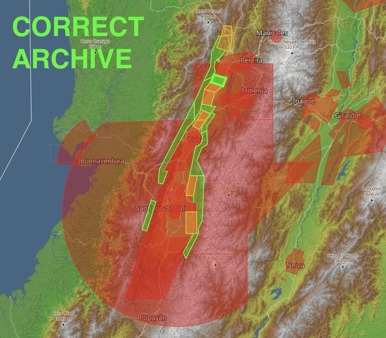
Information about the SK areas:
SKUL / TULUA (CTR) GND - 1520m AMSL: This airspace is currently not active (as of 4th of January 2025) as the military airport west of Tulua is not operational. BUT: Stay away from the Anti-Narcotic Military Base in the Southeast corner of Tulua where helicopters are frequently operating from and they are not a fan of paragliders especially, since someone landed inside their base. When flying by Tulua stay stay east of the highway.
SKR5 Norte (GND - 1980m AMSL): Buga area): Restricted airspace of the Colombian Airforce - no entry for paragliders permitted.
SKE (various): Training areas for conventional aviation- no entry for paragliders permitted. Small planes fly here frequently.
3. Please don't be that pilot!
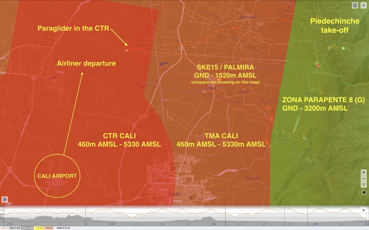
I have nowhere in the world seen this type of reckless behavior from the paragliding community than here in Colombia. In the image below you can see a pilot flying into CALI CTR, exactly where the Cessna pilot climbed out from the airport in the second example below. One reported near miss like that near the airport or god forbid a collision, and everything is screwed. I know from very good sources with connections to the authorities and air-traffic control that they know what we are doing and you need to understand: for those people we are presenting a huge threat.
Below: This type of irresponsible and dangerous flights are happening on a daily-basis during the high-season in Piedechinche by visitor pilots, but also some locals (plenty of evidence online) and will ultimately lead to shutting down paragliding here all-together or making it even more restricted. You are only on holiday here and will return to your home, but the mess you leave behind will affect hundreds of families who are making a living off the paragliding industry in one way or another.
UNDERSTANDING CALI AIRPORT APPROACH AND DEPARTURE:
The following screenshots are only a few random examples captured while working on this page (4th Jan 2025). These patterns look normal right now, but I am sure if I watch long enough, there will be all sorts of variations that I am not aware of due to heavy traffic or emergencies.
Which to me means: We need to keep more margin!
CLO departure:
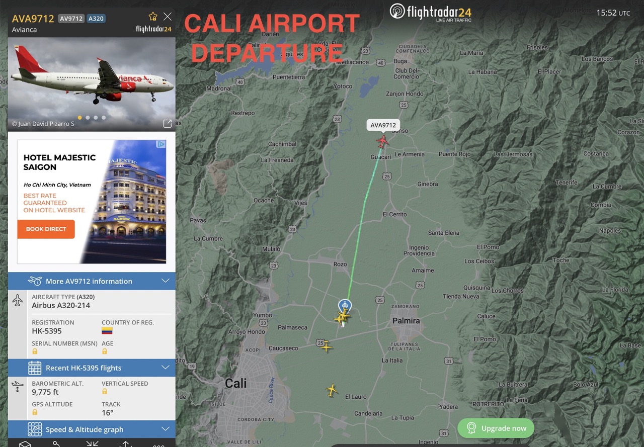
Example 1.
Note that the plane climbing out above Guacari is still below 3000 meters at 9775 feet!
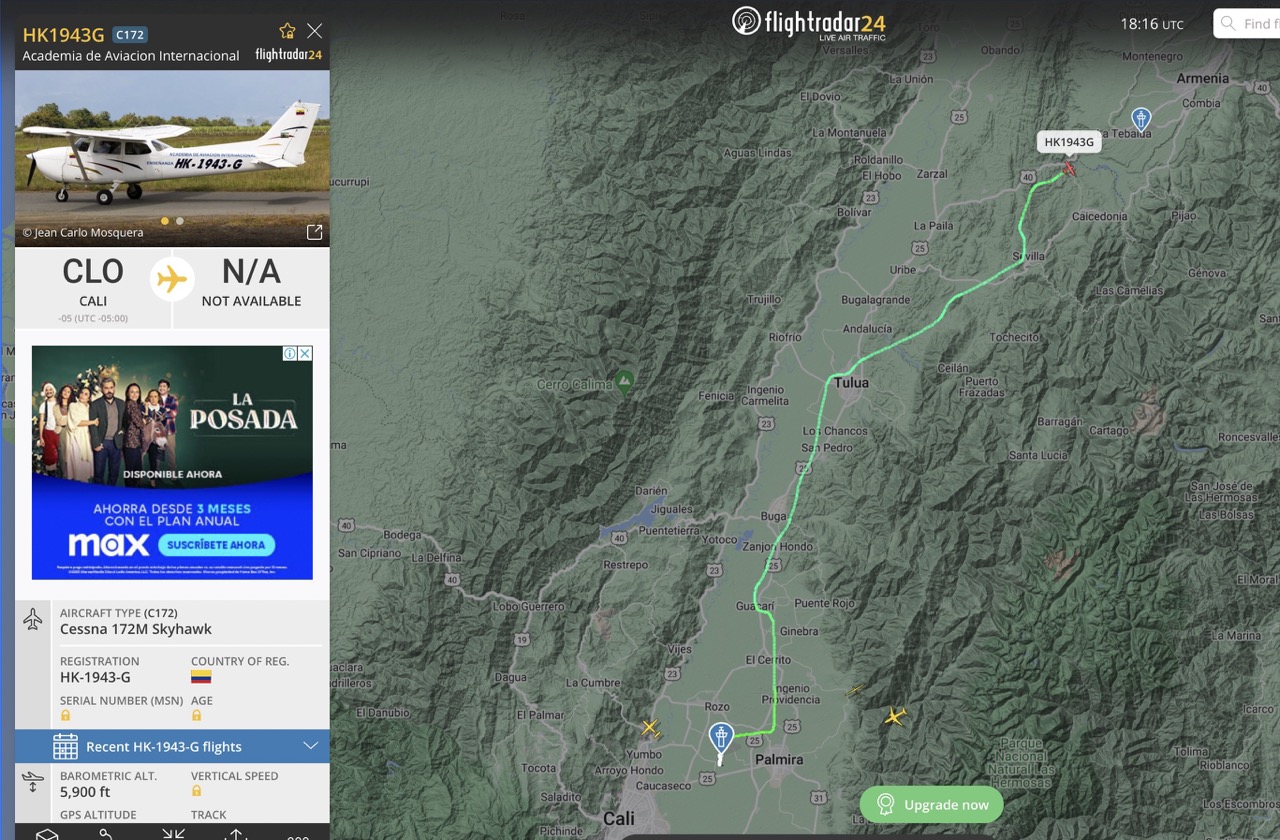
Example 2.
Small plane takes sharp right turn after departure turns east towards Palmira and then North flying East of the highway at Cerrito and Buga.
CLO Approach:
In most cases the airliners approach CLO airport from the north and descend southbound over the eastern half of the valley or come from further east over the mountains, followed by a right turn for the final approach from the south.
Example 3.: Cartagena-Cali flight (Same as Miami-Cali)
In this type of approach, the descent begins North of Tulua, and around Palmira the planes are descending well below 3000m AMSL!!!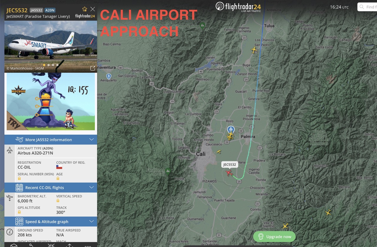
Example 4. (Bogota-Cali, etc.)
In this approach, the planes enter the valley descending below 4000m AMSL. Note that many times they stay more parallel to the mountains and fly further south before they turn resulting in possible near encounters in the Pradera area!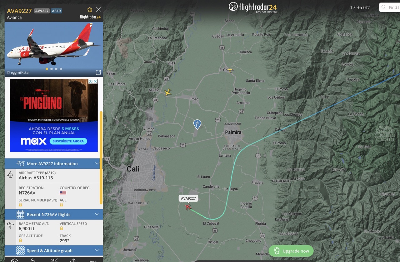
So what?
Our beloved Cauca Valley is unfortunately not only one of the most popular paragliding destinations in the world, but also one of the most restricted one.
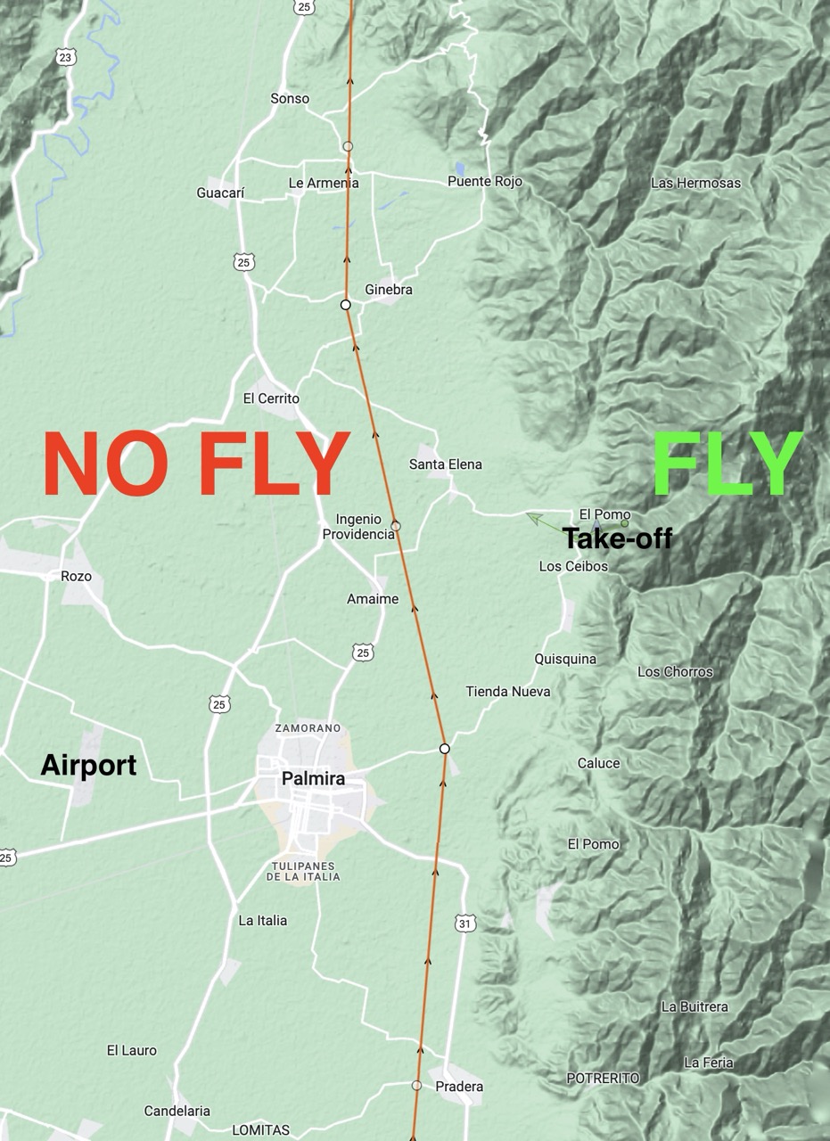
In Piedechinhe it is practically impossible to make a legal flight other than a sledder to the landing field or by staying high in the mountains. This fact needs to be clear for everybody. If we want to have a chance to continue to fly here, we, as the whole community need to educate each other and stay within reasonable limits. Here, the mountains are often shady, and the only way to fly XC is to go after the sun in the valley. But there needs to be an imaginary hard limit.
I disagree with several guides who come here with large groups, but even some experienced local XC pilots who brief that the "limit" is the highway. This is already a huge problem, because:
1. According to this you could still collide with a departing plane in the north and a descending plane in the south
2. The road from the Ingenio Providencia (sugarcane factory) to Amaime and further towards Palmira is actually not a highway so people fly further west to the highway and right in front of Cali control tower.
3. The highway is not parallel to the patterns of the planes.
After 8 seasons and probably over 1000+ hours flown here, watching every plane in the sky, I am highly suggesting for everybody to follow this recommendation:
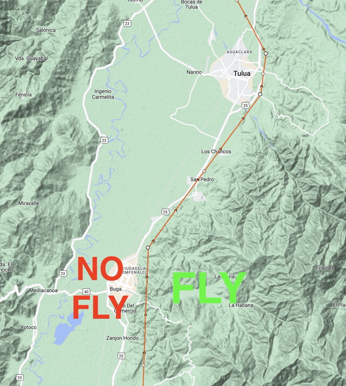
These are my personal rules from South to North (see maps below).
Pradera: inside or as close as possible to ZONA PARAPENTE, maximum slightly west of the main road (it is not recommended to land near Pradera or fly any futher south from there due to security concerns)
Palmira: STAY AWAY!
Tienda Nueva, Barrancas: Stay inside or as close as possible to ZONA PARAPENTE, maximum the junction area off the main road to Barrancas.
Amaime, El Placer: STAY EAST AND NEVER HIGH! You are right below CLO approach here!
Providencia sugarcane fabric: STAY EAST AND NEVER HIGH! You are right below CLO approach here!
Santa Elena: Stay inside or as close as possible to ZONA PARAPENTE, maximum slightly west of Santa Elena.
Ginebra, Puente Rojo, Costa Rica: Stay inside or as close as possible to ZONA PARAPENTE, maximum slightly west of Ginebra.
Sugarcane fabric "Pichichi": no further west from here. Beware that there is a nearby airfield Pichichi factory also has its on airfield, watch for traffic at all times!
Buga: Departure AND Approach corridor for big planes! Stay inside or as close as possible to ZONA PARAPENTE. Stay East of Buga in the mountains and only go to the valley to land. This is a tricky section with limited landing options.
Tulua: Stay inside or as close as possible to ZONA PARAPENTE and stay East of the highway away from the Anti-Narcotics base!
In the North of the Valley: Respect the CTR's and TMA's of Cartago, Pereira and Armenia.
Thank you and enjoy Colombia!
Pál
